Cctv newsAccording to China Weather Network, today (December 17th), the impact of this round of strong cold wave weather basically ended, but from tomorrow to 20th, a new cold air will supplement the southward impact on the central and eastern regions of China. Affected by the strong cold wave and the subsequent supplementary cold air, the temperature in most parts of central and eastern China will continue to be low in the coming week. In addition, there were frequent rainy and snowy weather in the south before the 19th, and Guizhou, Hunan and other places should be alert to the adverse effects brought by freezing and rainy weather.
A new cold air "arrived", and the temperature in the central and eastern regions continued to be significantly low.
Yesterday, the strong cold wave continued to go deep south, and the temperature in Jiangnan and South China plummeted. Monitoring shows that at 5 o’clock this morning, compared with 5 o’clock yesterday, some areas in Beijing-Tianjin-Hebei, Northeast China, southern South China and other places experienced a temperature drop of 6 ~ 10 C, and the local drop in southwestern Guangxi and southern Guangdong coastal areas reached 12 ~ 16 C. This morning, the temperature of 0℃ was linearly pressed to the southwest of Shaanxi, central Hubei, northwestern Jiangxi and central Zhejiang. The lowest temperature in 30 national stations in Hebei, Shanxi, Beijing, Tianjin and Liaoning exceeded the historical extreme value in December, and five stations in Shanxi, Hebei and Liaoning broke the historical extreme value since the establishment of the station.
On the morning of December 16th, due to the strong cold wave, Weihai, Shandong Province suffered from heavy snowfall. (Photo/Song Yongqiang)
It is expected that today, the impact of this round of strong cold wave weather will end, some areas in the north will pick up, and the local maximum temperature in Shanxi and Inner Mongolia will increase by about 10℃.
However, the cold air has not "died down". From tomorrow to the 20th, there will be a new cold air supplement to the south, which will affect the central and eastern regions of China from north to south. The temperature in some areas will drop by 4 ~ 8 C, and the temperature in some areas of Liaoning will drop by more than 10 C.
In the coming week, the temperature in the central and eastern regions will continue to be low. The daily minimum or average temperature in Northeast China, North China, Huanghuai, Jianghuai and northern Jiangnan is more than 5℃ lower than the historical period, and some areas are more than 7℃ lower. Especially around the 20th, parts of Northeast China and North China may be colder than during the current cold wave, so the public should pay attention to keeping warm.
Frequent rain and snow in the south, Guizhou, Hunan and other places need to be alert to disasters caused by freezing rain.
In terms of precipitation, in the coming week, due to the control of dry and cold air masses, the northern part of China will be mainly sunny and cold. In Guizhou to Jiangnan and other places, there will be frequent rain and snow weather before the 19th. Due to the continuous low temperature, the phase of rain and snow in many places is complicated.
The Central Meteorological Observatory predicts that there will be small to medium snow or sleet in parts of southern Xinjiang Basin, eastern Tibet, southern Qinghai, southeastern northwest, western Huanghuai, central Anhui, most of Jianghan, western Hunan, northern Sichuan Plateau, eastern Chongqing and central and northern Guizhou today. There is light rain in most parts of Jiangnan, Guangxi, northern Guangdong, Hainan Island and Taiwan Province Island.
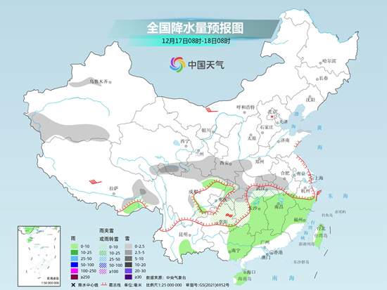
Tomorrow, there will be small to medium snow or sleet in parts of eastern Inner Mongolia, southern Jilin, central and eastern Liaoning, eastern Tibet, southern Qinghai, northwestern Jiangsu, eastern Hubei, northern and western Hunan, and central and eastern Guizhou, among which there will be heavy snow (5-6 mm) in parts of central and southern Anhui and southern Jiangsu. There is light rain in most parts of the south of the Yangtze River, southeastern part of Southwest China, most parts of South China and Taiwan Province Island, among which there is moderate rain in parts of southern Jiangsu, Shanghai and northern Zhejiang.
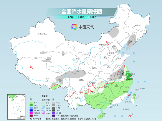
The day after tomorrow, there will be light snow in parts of southern Jilin, central and eastern Liaoning, northern Xinjiang and Ili Valley, eastern Qinghai, Shandong Peninsula and northern Sichuan Plateau. There is light rain in parts of southern Jiangsu, Shanghai, southern Hunan, southwestern Jiangxi, Zhejiang, most of Fujian, southwestern Guizhou, southeastern Yunnan, most of southern China, and most of Taiwan Province Island.

Special attention should be paid to the freezing rain in Guizhou and Hunan. The freezing rain in these areas is the widest this morning and tomorrow morning. China Weather Network reminds that the freezing rain may cause power lines to freeze and roads to be slippery, which will have a great adverse impact on energy security and transportation. Relevant departments and the public need to take preventive measures in advance.
关于作者