Weather in Beijing: It turned sunny to cloudy on the 7th, and the wind was strong.
Weather forecast in Beijing:
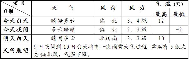
According to the latest forecast of Beijing Meteorological Observatory at 6 o’clock on the 7th, it will turn sunny to cloudy during the day, with northerly winds of Grade 3 and 4, and cloudy to sunny at night, with the temperature ranging from 12℃ to -2℃. Some suburbs and mountainous areas have road icing, which reminds us to pay attention to traffic safety. It is estimated that there will be a rain and snow weather process from the 9th to 10th, and the rest of the week will be mainly sunny to cloudy.
Weather forecast in Beijing area
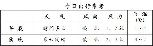
7-Day Air Quality Forecast and Life Meteorological Tips in Beijing;
Air quality grade: Grade 3, slightly polluted; The primary pollutant is inhalable particulate matter.
Dressing meteorological index 6: the temperature is low in the morning and evening, and the north wind is obvious in the afternoon. It is best to wear thin winter clothes with good windproof effect when going out, and add more coats in the morning and evening;
Cold meteorological index 4: the temperature difference between indoor and outdoor is large in the morning and evening, and the air is dry, which is easy to cause a cold;
Wind-cold meteorological index 2: the somatosensory temperature is 2 ~ 3℃ lower than the air temperature, and it feels cold.
Life tip: Although the highest temperature in the daytime today has not changed much compared with yesterday, there are 3 or 4 northerly winds in the afternoon, and the somatosensory temperature is lower. Please pay attention to wind protection and warmth.
[Extended reading]
National weather situation:
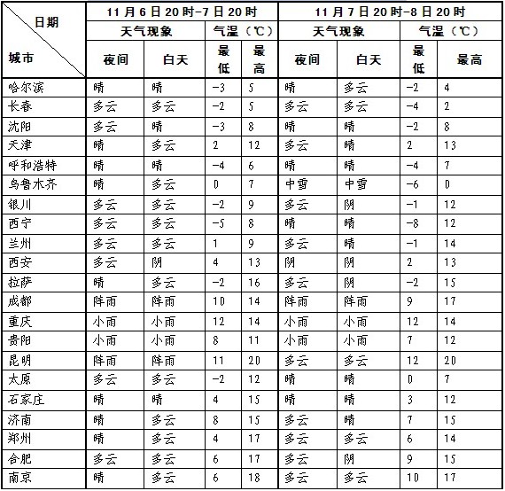
From this morning to this morning, there was fog in Jiangsu and other places, and the visibility was less than one kilometer. The public should pay attention to the road conditions and slow down; In the next three days, cold air will all appear, bringing strong winds to cool down to the northern region; The center of gravity of rainfall in the southern region will move from southwest to east, and the rainfall intensity will increase and the scope will gradually expand. There are light fogs in the southeastern part of Northeast China, south-central North China, Huanghuai, northern and eastern Jianghuai, and northeastern Jiangnan. Among them, most parts of Jiangsu, northern Zhejiang, and southeastern Jilin have fogs with visibility less than 1 km.
National weather trend forecast:
It is expected that weak cold air will affect the northern region from July 7 to 8; From August 8 to 11, affected by a new strong cold air, the temperature in most parts of the north dropped by 4 ~ 8℃, and the local temperature could reach 10 ~ 12℃. Most of the north is accompanied by northerly winds of 4 ~ 6, and the wind power in Shankou, Xinjiang can reach 8 ~ 9. At the same time, from the 7th to the 8th, there was little to medium snow or sleet in northern Xinjiang, among which, some areas in Tacheng, Altay and the western Tianshan area had heavy snowstorms.
From July 7th to 10th, it was rainy in most parts of southwest China, south China and south China, with heavy rain or rainstorm in parts of eastern and southern Guizhou, northwestern Guangxi and north-central Jiangnan.
In the next 24 hours, there will be small to medium snow (rain) or sleet in northern Xinjiang, northeastern Tibet, southeastern Qinghai, southern Gansu, northeastern Inner Mongolia, northern and eastern Heilongjiang, among which, some areas in Tacheng, Altay and along the Tianshan Mountains in Xinjiang have heavy snowstorms (6-15 mm). There are small to moderate rains or showers in the southeastern part of the northwest, Jianghan, western Jianghuai, most of the south of the Yangtze River, southwestern China, and central and western South China. Among them, there are heavy rains (25 ~ 40 mm) in parts of western Yunnan, eastern Guizhou, central Hunan, and northwestern Guangxi. There are 4 ~ 6 winds in northern Xinjiang and other places, and the wind power in Shankou area can reach 8 ~ 9. Some parts of the southern Xinjiang basin have sand blowing or floating dust.
In view of the invasion of cold air in the north, meteorologists remind the public to keep warm and cold to prevent colds; The precipitation in the south is increasing gradually, and the local rainfall is relatively heavy. It is suggested that the mountainous areas should pay attention to prevent possible geological disasters.
Meteorological services focus on:
1, northern Xinjiang, Inner Mongolia and the eastern part of northwest China, such as rain, snow, cooling and strong winds, have adverse effects on agricultural production and animal husbandry.
2. The adverse effects of strong precipitation in western South China and south China on agriculture.
3. Local disasters that may be caused by precipitation in the east of southwest China.
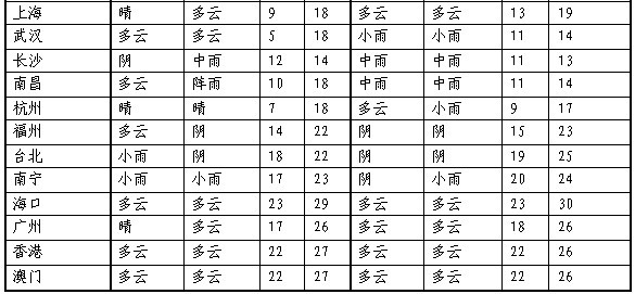
Weather forecast of other provincial capital cities in China